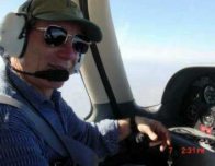
Cirrus Line # 62 Delivery Flight
Chapter 2-The Sandel Experience
"
Odyssey" may be too grand a term to apply to our delivery flight of Cirrus line number 62, but the experience certainly felt like that scale of adventure. We explored the altitude envelope of the airplane from low level "beach" flying to 14,000 feet over some 38-flight hours. We flew two test flights integrating the new Sandel 3308 EHSI (Electronic Horizontal Situation Indicator). We flew through a major front that generated significant mountain wave action. We "threaded the needle" through a weather system involving high MEA’s, low freezing levels, and 40-knot head winds. So it felt like an Odyssey!

Chapter one of this journey took us from Duluth to San Diego, where Mark Mahan of Sandel and Dave Hainline of Ramona Avionics in Ramona, CA installed the SANDEL EHSI. In addition to the EHSI, Mark and Dave gave us some "freebie" improvements to the SR20 flight deck: they tweaked the STEC autopilot disconnect sound volume down to a tolerable level, and they adjusted the overly bright clock so it was less of an unwanted spotlight during night flight.
It took two test flights to get the STEC autopilot adjusted to receive the Sandel EHSI instead of the Century signal levels. Discussions between Mark and STEC determined the proper resistors in the autopilot, and the second flight produced good performance in heading and NAV response. The tracking was still offset by about a needle and a half, so Mark loaned us an autopilot tracking adjustment tool and we tweaked the tracking performance during the flight to Seattle. During Del’s last flight he got the heading tracking down to less than a degree error.
Which of course highlights one of the great features of the Sandel 3308 EHSI. The precision of the graphical and alphanumeric indications is unbelievable, and makes possible great instrument flight performance not available this side of heavy jet equipment. You don’t guess at drift angle with this instrument; you know the effect of crosswinds down to the degree. Using the Sandel data with the Garmin 430’s, it gives you a smug feeling to provide a PIREP to Flight Service, casually reporting "…and the wind at one two thousand is 341 degrees at 37 knots!"
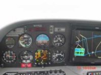
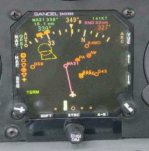
At first glance the Sandel 3308 information density is imposing. You have selected mode, a moving map display, course (and glide slope) deviation, display option icons, Stormscope information, heading and course pointers, two bearing pointers, alphanumeric data on actual and selected heading, track, range, selected way point, and more, all contained within a three by three inch surface. Seems like a lot and it is; but the human eye does a phenomenal job of selecting what is needed for each situation. Information presented on the EHSI is well organized and makes good use of consistent color-coding. Display symbols are sharp and clear. Explore
www.sandel.com and you will get exposed to the possibilities and versatility of the instrument.
Living with the Sandel for 12 hours during the test flying and ferry to Seattle highlights the functional simplicity of operation. The nine control buttons are logically labeled, and the sub menus accessible through the SHFT button are intuitive to operate. There is a "progressive learning" sense about the instrument, and every time you need new data; i.e. to satisfy an ATC position reporting request, a little experimenting and, behold! there it is right on the display. We are not advocating ignoring Sandel’s excellent Pilot’s guide, because set up and expression of the pilot’s personal preferences requires deeper knowledge of how the display works. But unlike the Garmin and the ARNAV systems, you can get in the airplane and start pushing Sandel buttons with a fair likelihood of getting the desired result right off the bat!
Here is a play-by-play summary of the journey, starting at Ramona where we left off on Friday, October 13th, in the previous article:
- Between October 13th and November 6th, Mark and Dave and their teams worked on the airplane installing the 3308 EHSI and completing the Sandel compliance paperwork. This installation creates the STC (Supplemental Type Certificate) that Sandel will use for retrofit and Cirrus will use to offer the 3308 as a standard option on the SR20 and SR22. Our installation gives us complete access to both the #1 and #2 Garmin 430’s. As we understand it, the Cirrus standard option will limit the course deviation display to the #1 430, though bearing pointers to both 430’s will be available. Our airplane is certificated under a FAA form 337, however, there is still some work needed to refine the POH supplement for our airplane and complete the conformity review for the STC.
- The local FBO changed the oil and fixed a broken spring on the throttle linkage, which improved the feel of the throttle lever.
- On Monday afternoon, November 6th, Del and Dave flew a test flight and determined that the S-TEC55 configured for the Century HSI needed new resistors to accept heading input from the Sandel. We ferried the airplane to Palomar airport (KCRQ) that evening. Mark took the S-TEC back to the bench for modification.
- On Tuesday morning, November 7th, Del flew a second test flight with Mark and Gerry Block, President of Sandal; the S-TEC performed perfectly. Gerry got some stick time, and remarked at the control harmony saying it "…was the best flying light plane he has flown!"
About noon, we serviced the oxygen; flight planned for an overnight at Redding, and launched North with Peter in the left seat. The days were getting short in the Pacific Northwest, and we preferred to deal with the forecast weather conditions during daytime temperatures. We flew at 10,000 feet and encountered 30 to 40 knot winds for portions of the route. This was our longest non-stop of the journey, with 4.6 hours on the Hobbs.
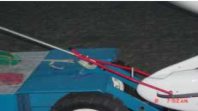
- We were well treated at Redding by the FBO, Sun Air. Together, we improvised a pretty effective solution to towing and pushing the SR20 with the nose wheel off the ground; the photo shows the detail of that operation.
- Wednesday morning November the 8th, we were greeted with a complex weather situation: freezing rain and cloud conditions were reported over the usual Siskiyou mountain route to Washington up to 24,000 feet. We flew a local pleasure flight to Red Bluff for landing practice while we waited until the freezing levels along the route moved higher at the 11:00 a.m. weather report. The Siskiyou’s were still blocked, but the reported cloud tops of about 13,000 over the coast were more benign, and within the performance capability of the SR20. We filed an IFR plan to Boeing Field (KBFI) which took us over Crescent City, and thence along the coastal route northbound as far as North Bend and then inland over Eugene. The winds were still around 40 knots from the Northwest, and we planned to come inland where the freezing level was forecast above the MEA North of the Siskiyou’s. This preserved the option for overnight at Eugene, Oregon, if the actual weather proved inhospitable.
- Del flew the leg out of Redding with Peter doing the communications and Garmin work. We climbed out at maximum gross weight to 12,000 ft, and later to 14,000 feet to overfly the coastal cloud buildups. This was one time we would have liked the horsepower of the SR22; it takes a long time for the SR20 to reach 14,000 ft. But Oakland Center was patient with us, and we eventually got there. Our experience in high altitude flight with the Cirrus suggests that flying the published maximum rate of climb speeds does not work very well at high altitudes. There seems to be a "drag bucket" at about 110 to 115 knots indicated where the SR20 will climb about 300 feet per minute at maximum weight on a standard or warmer day. We used this technique to get to 14,000 ft on this flight just as we had done crossing the Rockies on the trip from Duluth to Ramona.
- The cloud heights and distribution worsened as we approached North Bend, so we headed inland toward Eugene in mixed atmospheric conditions. We were in VMC (visual meteorological conditions) flying IFR, but the weather was clearly getting worse the farther north we flew. Every time we flew into a cloud, however briefly, a trace of ice would appear on the leading edges. Other aircraft, including some airliners, were reporting light to moderate ice buildup in clouds between 11,000 and 7,000 feet. We had been airborne for 2.9 hours, and continuing the flight plan to KBFI would have had us at marginal fuel levels on arrival. We found a hole, and with cooperation from ATC, descended through the freezing level at 6000 feet without serious ice encounters and then flew in heavy rain and ice pellets at 5000 feet breaking out into clear air just south of Eugene.
- On the ground we used the Flightcraft FBO’s well-equipped planning facility to check the weather between Eugene and Seattle, and saw some really nasty conditions around and east of Portland between the coastal and Cascade mountain ranges. Seattle and the Puget Sound lowland weather was generally VFR with scattered clouds in layers. Once again we thought about the possibility of going to the shoreline where the buildups were more widely scattered. After refueling, it was within about an hour of sunset, so we left VFR to explore the options over the hills to the coast.
- We’ve heard comments that there can be adversarial relationship between GA pilots and controllers; our experience on the entire trip from Duluth has been otherwise. The tower operator at Eugene volunteered flight following as we taxied out. We needed a "pop-up" IFR clearance to get over the hills while "threading the needle" at the MEA, carefully avoiding clouds when we had to fly above the freezing level. Cascade Departure was very cooperative and allowed plenty of lateral leeway to dodge the clouds and allowed us to stay VFR on Top. This accommodation occurred while the controller was occupied with rapid fire control of airline traffic; he slipped us in without missing a beat!
- Our plan was to cancel IFR and progress VFR up the coast a mile or two off shore to Astoria because the IFR MEAs along the airway were well above the freezing level. We were prepared, if necessary, to land and overnight at whatever airport presented itself before sundown, be that Newport, Tillamook, or Astoria. The plan worked out perfectly and as the sun went down, we overflew Astoria.
- At Astoria, Seattle Center provided another "pop-up" IFR clearance via Hoquiam to Boeing Field on Victor 27 which has an MEA of 4000 feet; just 1000 feet below the freezing level in that area. Again, kudos to ATC who usually prefer a higher altitude but accommodated our needs with grace.
- As it got dark we flew through showers of mixed rain and snow. Our strobe light lit the path of each droplet creating a matrix of "fireflies" off both wing tips; a beautiful sight, a fitting visual
climax to the extraordinary skyscape we had experienced all the way from Eugene
Once passed the south flank of the Olympic Mountains, the bright lights of the Puget Sound basin gave a warm glow to the scattered cloud bottoms while the nearly full moon turned the tops to silver. All too quickly we were on the ground at Boeing Field taxiing in familiar territory.
Altogether, it does seem like an Odyssey more from the variety than the length of the adventure. The Cirrus performed brilliantly, and we could not be more pleased with the airplane. However, we are still engineers of the aeronautical persuasion (see chapter one of this saga for credentials), therefore we are always thinking about possible improvements.
So, we asked ourselves: "What would we want to be different after experiencing the Cirrus operation with the two Garmins, the ARNAV MFD, and the Sandel? Here are a few comments:
- The flight deck is clearly equipped with three different manufacturers who have different human factors design ideas about the pilot interface. We would rank the Sandel as most user friendly with a very intuitive interface, the Garmins next with plenty of study required but good consistency among the functions, and the ARNAV as a useful reference that requires considerable experimentation to learn how to use it well. The ARNAV display of airspace altitude restrictions in unfamiliar class B airspace is a superb orientation and situational awareness tool
. We have established a relationship with ARNAV and they seem interested in our comments, so stand by for possible changes down the line. In any event, the pilot has to integrate the different display operational strategies and that requires some time in the airplane and some study work. The Garmin CD ROM training aid is an excellent tool for mastering the logic of the device in the comfort of your living room, without having to worry about conflicting traffic. However, nothing but time operating the real thing will develop the habits and manual skills necessary to make the 430’s sing.
- Our Cirrus is now on line with the Wings Aloft flying club at Boeing Field in Seattle. The club will require pilots who check out to acquire their own copies of the SR20 POH, the operating handbooks for the Sandel EHSI, the STEC autopilot, the Garmin 430, and the Garmin CD ROM. The current handbook for the ARNAV MFD does not reflect the Cirrus configuration, so at the present time, the MFD needs to be mastered through instruction.
- With four moving map displays in the flight deck (two Garmins, the MFD, and the Sandel), it would be good to see some standardization of symbology and colors among the displays.
- The Sandel EHSI is locked into a "Heading Up" display. For consistency, it would be nice if it offered a "Track Up" display option since the other maps do not have a compass input and are not able to show "Heading Up". Flying with a twenty knot crosswind component makes the difference in track and heading up display obvious and a little confusing.
- It would be nice if the Garmin geographic data could be viewed on the ARNAV MFD, which has so much more area available. The MFD’s built in geographic data is significantly less detailed by comparison.
- With the installation of the Sandel, there are now at least four and possibly as many as six Jeppesen databases that a pilot must maintain and pay for. (The number "six" applies if the pilot has a subscription for navigation charts and owns a computer flight-planning program like FliteStar.) Of all these data bases, at least two (the pilot’s paper charts and one of the Garmin’s) must be maintained current on the Jeppesen 28 day revision cycle to keep the pilot and aircraft IFR capable. The Garmin data generates the flight plan and way point information displayed on the MFD and Sandel, and thus must be current. The MFD and Sandel data bases require less frequent updates because all they provide is independent generation of background data such as location of airports, airspace Class information, VOR’s, and intersections, which rarely change. It would be nice if the Garmins could act as a "master" and have the others be "slaves" so that logistics and costs of maintaining consistency within the flight deck would be simplified.
Again, we are happy campers with the SR20, and the equipment in our airplane with the Sandel installed is extraordinary. We hope that all the pilots who fly line number 62 will like it as much as we do.
Del Fadden:
[email protected] Peter Morton: [email protected].